

This area was gazetted as a reserve in 2002.
However, in the early 1960s, the Uganda Game Department sought to exert more control over sport hunting in Uganda by declaring certain areas to be Controlled Hunting Areas (CHAs) in which sport hunting could only be carried out by special license, and against carefully set quotas.
The Kaiso-Tonya area on the shoreline of Lake Albert was gazetted as a CHA in 1963 as it harboured isolated but important populations of Uganda kob, buffalo and hartebeest. Game Department records indicate that hunting in Kaiso-Tonya CHA, and in its smaller neighbor Buhuka CHA, was properly regulated until the mid-1970s. Thereafter, with the breakdown of law and order in Uganda, no further management of either area took place for the next 20 years.
The Kabwoya-Kaiso Wildlife Management Area (KKWMA) is in Hoima District and covers the majority of the land formerly known as the Kaiso-Tonya Controlled Hunting Area. The KKWMA has a total area of 194 sq. km and comprises the Kabwoya Wildlife Reserve (KWR, area 87 sq. km) and the adjacent Kaiso-Tonya Community Wildlife Area (KTCWA, area 107 sq. km).
The Hohwa River separates KWR and KTCWA. The KKWMA is bounded on the east by the foot of the Albertine Rift escarpment, to the west by the shoreline of Lake Albert, to the north by the Lwamagongo River, and to the south by the Warwire River. The KWR has been surveyed and boundary beacons installed.
KKWMA is the only relatively ecologically intact area of savannah along the 200 km stretch of Lake Albert shoreline between Toro-Semliki WR in the south, and to Murchison Falls NP in the north. In its position in the Rift, and with its proximity to the large Bugoma Forest Reserve, the KKWMA is of great importance in maintaining corridors for genetic flow in the Albertine Rift.
Kabwoya falls within one district, Hoima and is surrounded by 3 sub-counties namely, Kabwoya, Kyangwali and Buseruka.
ACCESS
The area is accessed by road from Hoima which is a distance of 82 km. The road was in a poor state before the oil activities started in the area. The road has been upgraded to bitumen which has greatly improved accessibility into the reserve.
LANDSCAPE
The dominant features of the KKWMA are the Albertine Rift escarpment to the east, Lake Albert to the west, and the Hohwa River that bisects the two zones of the concession area. The main area of KKWMC is a gently sloping shelf of land between the escarpment base and the lakeshore. In the central part of the shoreline, the shelf drops to the lake in a small steep escarpment of 70 m height. Elsewhere along the shoreline, the gradient is shallow to the beach, providing for the establishment of many fishing villages. In terms of geology, the area is comprised of alluvial sands, which are easily eroded; this area was once the floor of Lake Albert.
FLORA
The vegetation primarily comprises Hyparrhenia and Themeda grassland interspersed with patches of the undifferentiated dry thicket with Grewia spp and Acacia brevispica (Langdale-Brown 1964). Along the Hohwa River are stretches of riverine forest.
FAUNA
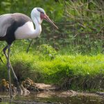
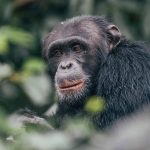
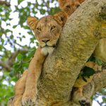
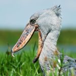
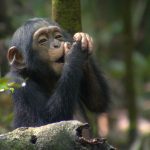
The various census surveys carried out in the area indicate significant populations of Uganda kob, bush duiker, oribi, warthog, bushbuck, bushpig and colobus. There are small populations of hippo and buffalo. The main large carnivores are leopard and hyena. The most significant „flagship‟ species is chimpanzees, which are found in the riverine forest along the Hohwa River. Species once recorded in this area, but are now absent, are Bohor reedbuck, hartebeest and giant forest hog. Three male waterbuck have also been spotted on the reserve.