
Africa’s most epic mountain climbs – Alpha Adventure Safaris
Our guide of Mountain climbing in Africa, the top hiking destinations and advice. Where To Go For Mountain Climbing in Africa
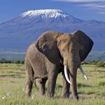
1. Mount Kilimanjaro
Mount Kilimanjaro is located in the Kilimanjaro Region of Tanzania and it has got an elevation of 5,895m (19,341ft), with Prominence, its 4th and its Isolation is at 5,510 kilometers (3,420mi). It’s a strato volcano mountain and its last eruption happened between 150,000 and 200,000 years ago. This Mountain has got three volcanic cones including; Mawenzi, Shira and Kibo and it’s a dominant Volcano in Tanzania. Kilimanjaro Mountain is the highest mountain in Africa and rises over 4,900m (16,000ft) from its base above sea level. Its first ascent to the summit was by Hans Meyer and Ludwig Purtscheller in 1889. This famous mountain is also part of Kilimanjaro National park and it’s the major climbing destination in East Africa.
The mountain has got over seven known trekking routes which includes; ascending and descending mount Kilimanjaro: these routes include;’ Machame, Mweka, Lemosho, Marangu, Shira, Rongai and Umbwe. And of all these routes, Machame is the most scenic and steeper route, this is because it can be completed in 6-7 days. Among all the above routes, Rongai is the easiest and least scenic route. More so, the Morangu route seems to be easy but tends to be so busy. However, the mountain ascent and descent routes are the same and the accommodation facilities are usually shared in the huts with many other climbers. The mountain climbers are always advised to make research about the different routes and should also ensure that they are well equipped and capable physically. The Hike is usually made difficult by the high elevation, occasional high winds, and the low temperatures.
Kilimanjaro rises 4,900m from its southern base with in the plains that are near the municipality of moshi towards its height of 5,895m and this means that it’s the highest volcano located outside South America, this mountain is comprised of many volcanic cones including; Mawenzi, shira, these two are extinct while Kibo cone is dormant and could erupt again which is a danger to the climbers.
2. Mount Kenya
This is the highest mountain in Kenya and it’s second to Kilimanjaro Mountain which is the highest mountain in Africa. Its highest peaks include; Batian which is 5,199m ( 17,057ft), Point Lenana (4,985m (16,355ft), Nelion ( 5188m (17,021ft). this mountain is located in the Centre of Kenya and its about 16,5 km south of the Equator and 150km northeast of Nairobi , the capital city of Kenya. The mountain is also the source name to the Republic of Kenya. It’s also a strato volcano and was created 3 million years ago. The mountain is over 7000m (23,000ft) above the sea level and it’s covered by an ice cap for the many years it has existed. It has got eleven small glaciers and its forested slopes are so important for providing water to many parts of Kenya. The other types of vegetation cover around the mountain includes; Lobelias, Rock Hyrax and the senecious. Part of its area (715km) was designated as a national park called Mount Kenya National Park and was listed as UNESCO World Heritage Site in 1997.
The mountain has many peaks that require rock climbing. Most of these peaks have been summated and majority involve rock climbing and considered as the easiest route, even though some require walking. One of the highest peak that can be ascended without climbing is point Lenana which is 4,985m (16,355ft), this peak is mostly climbed by majority of the visitors that come to the park. The other peaks of Nelion and Batian are climbed by few people since they are the highest peaks. The Batian was first ascended on 31st/ July 1944 by Hicks and Firmin. This route is climbed in 2 days. The mountain is also famous for the good ice routes, these include; Diamond couloir and the Ice Window route. The snow and the ice on the mountain has been retreating at a high rate in the past years, which makes the climbs so difficult and dangerous. This mountain has also got eight walking routes leading to the main peaks. These include; Kamweti, Naro, Moro, Chogoria, Meru, Burguret, Timau, and Sirimon route, the frequently used routes include; Chogoria, Sirimon, Moru and Naro and these have got staffed gates, the rest of the routes require special permission from Kenya Wildlife services to be used.
3. Mount Rwenzori
The Rwenzori Mountains was previously referred to as Ruwenzori Ranges, and sometimes it’s called the “mountain of the moon”, this is also a mountain range of the eastern equatorial Africa and its located on the border of Democratic Republic of Congo and Uganda. The mountain is at a height of 5,109m (16,762ft) above the sea level and its highest peaks are fully and permanently snow capped with Mount Kenya and Kilimanjaro. The Mountain harbors both Virunga National park and Rwenzori National Park. This mountain formed three million years ago in late Pliocene epoch and this was a result of an uplifted block of the crystalline rocks that include; amphibolite, Gnesis, granite and Quartite.
This mountain range is about 20km long and 65km wide and it has got over 6 massifs which are separated by deep gorges including; Mount Speke 4,890m (16,040ft), Mount Stanley 5,109m (16,762ft), Mount Emin 4,798 (15,74ft), Mount Baker 4,715m (15,469ft), mount Luigi di savoia 4,627 (15,180ft) and Mount Gessi 4,715m (15,449ft), Mount Stanley has got many subsidiary summits and Margherita peak being the highest point. The first European sightings of this mountain was by Henry Morton Stanley in 1889 and William Grant Stairs was the second to climb the mountain and reached a height of 3,254m. More so, the first ascent to the summit was made by the Duke of the Abruzzi in 1906. These mountains are known for hiking and mountaineering safaris, and a 9 to 12 day trek will get the skilled climbers to the top summit of Margherita which is the highest peak, even though they are shorter, the treks are possible to scale the nearby surrounding peaks. And for those climbers who prefer a little less trek, there are some neighboring Bakonzo villages that offer nature walks, home steads visit as well as cultural performances.
4. Atlas Mountains Morocco
The Atlas Mountains are also a mountain range found in the Maghreb. It reaches around 2, 500km (1600mi) through Morocco, Tunisia and Algeria. The highest peak of this mountain is called Jebel Toubkal and it has got an elevation of 4,167m (13,671ft) in the south-western Morocco. The mountains also divides the Atlantic and Mediterranean coastlines from the famous sahara desert. These mountains are mainly inhabited by the Berber people. It has also got variety of endangered plants and animals, some of these include; Atlas bear, Barbary Macaque, the animals include; the Barbary leopard, Barbary lion, sheep, Barbary stag, north African Elephant, atlas mountain viper, Cuvier’s gazelle, and many more.
The Atlas Mountain was formed during the three subsequent phases of earth’s geology. These are also believed to have originally been formed as part of the Alleghenian Orogeny. They were also formed when both America and Africa collided. This mountain has got many natural resources including; Iron ore, copper, lead ore, rock salt, marble, silver, Mercury, anthracite coal, phosphate, and the natural gas. The Atlas Mountains are divided in to four main regions including; Middle Atlas, Anti Atlas and High Atlas in Morocco, this middle atlas is in the western side of the three Atlas mountain chains that make a large plateau basin extending east wards. The high atlas also rise in the west of the Atlantic coast and also extends to the Moroccan Algerian boarder and the Anti-atlas extends from the Atlantic Ocean in the south west of Morocco. The second region is Saharan Atlas range which is in Algeria and in the eastern portion of the Atlas mountain Range, the Tell Atlas Range is over 1,500 km (930mi) in length and stretch from Morocco through Tunisia and Algeria and the Aure’s mountain range located in the Aures Region of Algeria and Tunisia.
5. Semien Mountains of Ethiopia
Semien Mountains are found in northern Ethiopian, north east of Gondar and are also part of the great Ethiopian Highlands. These are considered as a world Heritage site and they include, the semien National park. This unique mountain contains a plateaux that is separated by the valleys and the rising to the pinnacles. Its tallest peak is Ras Dashen (4,550m), the other heights also include; Kidis Yared (4,453m) and Biuat (4,437m). The animal species found here include; Gelada, caracal, the walia ibex and the Ethiopian Wolves. These mountains are known to be a great spot in Africa where snow never falls. This snow was first seen by Jesuit priest and later by Henry salt.
All the trekkers on this mountain follow the same common route along the ridge of the Simien mountains national park that passes a route from Sankaber to Geech to the Chenek camp. This famous trail can be completed in 3 to 5 days with the 4 x4s having the access to Sankaber and Chenek at the end of the trek. We also recommend 4 to 5 days on this same route since this will give you the time to go imet Gogo which is a stand out view and also climb Mount Buahit. More so, from Chenek, for those very keen with trekking from the longer distances have got many options. These are usually temped by the allure of Ras Dashen, which is Ethiopia’s highest peak, and apart from its altitude, this route has little to commend it. Many of the trekkers attempt a multi week move all the way to Lalibella, which is an incredible walk through the rarely visited parts. The trekkers to this mountains can also head to the low alnds via sonar, Mekarba and Mullet campsites, which is also a lovely route with much swimming spots in the rivers and are rarely visited camps.
6. The Drakensberg South Africa
The Drakensberg is a name that was given to the eastern portion of the great Escarpments, and this covers the southern African plateau. The Escarpment elevation reaches 2,000 to 3,000 m and the Drakensberg escarpment reaches for over 1,000km (600 miles) from the Eastern Cape Province in the south to the north, to the border between Lesotho and the Eastern Cape towards the Kwazulu Natal province. This is also the main mountain range in South Africa and rises to more than, 11,400 ft (3,475m). The rock and cave art has been found several years within the range. It has got many game reserves and parks and it was designated a UNESCO World Heritage Site. It’s also the main watershed of South Africa and it’s also the source of water to Orange River. The highest peak of the mountain is Thabana Ntlenyana at 3,482m (11,424ft), the other peaks include; Makoaneng at 3,315m, Mafadi at 3,450m, Njesuthi at 3,408m , Giant’s Castle at 3,315m, Champagne castle at 3,377m, popple peak at 333m, and Ben Macdhui at 3,001m
The other popular area for the hikers is cathedral peak. In the north of Lesotho, the ranges become lower and less rugged until it enters Mpumalanga where the great Quartzite Mountains of the Transvaal Drakensberg are seen at loftier state and broken from the eastern rim of the Transvaal Basin. You can chose between the day hikes, longer overnight trails or the walks which is the famous Giant’s cup trail. The Hikes vary in length from 1 to 8 hours. These hikes also include good views of the peaks of the area, most especially Hodgon’s paeka at 3,256m as well as the beautiful mountain streams, waterfalls, pools to swim, forests and the challenging scent. You can take up the beautiful views from the top of Ndlovini at 2,200m, stand at the base of the floating balancing rocks and sight the reedbuck, oribi, duikers, eland, grey Rhebok, baboons and the vultures during your hike.
7. Mount Meru of Tanzania
Mount Meru is also a dormant strato volcano that is located 70km (43mi) west side of Mount Kilimanjaro in Tanzania. It’s at a height of 4,562.13m (14,968ft) and it’s visible from Mt Kilimanjaro on a well clear day. It’s known to be the highest mountain in Africa. This mountain had a minor eruption in 1910, and the many small cones and craters around the mountain reflect the many episodes of volcanic activity. Its savannah grassland supports a forest which hosts variety of wildlife including; 400 bird species, leopards and the monkeys. The Momella Route which is 4km (.7mi) is the main and only route to the summit in the recent times. The route starts at the Momella gate (1,500m) and uses two tracks of Miriakamba Hut (2,514m/8,250ft) and saddle Hut route (3,566m/11,700ft). The Rhino point can give you the best amazing views of the summit as well as the inner crater walls. The trek to this mountain serves as an ideal warm up for the great Mt Kilimanjaro due to its altitude and the hiking distances. The trek also helps hikers who prefer less crowds as well as the challenging ascent.
Long ago, it was possible to reach the summit via the North and west slopes, but now days the use of these trails is illegal. It’s also legal to reach the inner Ash Cone and the park authorities recommend it for the researchers and also issues a special permit for this particular activity. The best and good time to climb the peak of Momella is from June to February with the occasional rains in November. This is because it’s a dry season. This hike can be began from Momella gate between 9:00 am and 3:00pm. This helps since it helps to avoid conflicts with the wildlife. Even though you would like to take the long route of up to Miriakamba hut and carry out the trip in 3 days, you will need to start the hike by 4:00am on the first day.
8. Mount Elgon, Uganda & Kenya
Mount Elgon is an extinct shield volcano located in Mt Elgon national park and found on the border of Uganda and Kenya and in the north of Kisumu and western part of Kitale. Its highest point is called Wagagai and the mountain is located in Uganda. It has an altitude of 4,321m (14,77ft) above sea level and it’s the seventeenth highest mountain in Africa. The mountain is 24 million years old which makes it the oldest extinct volcano with in East Africa. This mountain also covers an area of around 3,500 sq km (1,400 sq mi). It’s also known to be a solitary volcanic mountain on the border of eastern Uganda as well as western Kenya. The mountain is 80km in diameter and also rises over 3,070m above the nearby plains. It has got cooler heights that offer respite for the human beings from the hot plains below and the higher altitude that provides a relief to the fauna and Flora.
The park consists of five peaks including; the wagagai peak; (4,321 metres (14,177 ft)), located in Uganda, the Sudek peak (4,302 metres (14,114 ft)) located on the border of Uganda and Kenya, Mubiyi peak; (4,211 metres (13,816 ft)) in Uganda, Masaba peak (4,161 metres (13,652 ft)) also in Uganda and Koitobos peak ((4,222 metres (13,852 ft) which is a basalt column in Kenya. The mountain has got one of the largest intact caldera in the world. Hiking this mountain also presents an exciting setting of unique fauna and flora, caves, waterfalls, peaks, and the hot springs as well as the gorges. Hiking this mountain takes place the whole year but its better done during the dry months of June to August and December to March. Trekking here takes place every day and it’s not difficult to climb this mountain and the hikers need to be fit and there are no specialised equipment or skills are needed to reach the peak since the mountain is not so high.
9. Mount Cameroon
Mount Cameroon is known to be an active volcano with in Cameroon and it’s near the border of the Gulf of Guinea. It’s also called Cameroon Mountain or Fako ad it’s a name of its two peaks or the known native name called Mongo ma Ndemi. It’s the highest point in the sub Saharan western and the central Africa. This is also the most prominent peak in Africa and it gets the 31st position in the whole world. The mountain is one of the largest volcano in Africa and rises to 4,040m (13,255ft) above the coast of West Cameroon. It rises from the coast tropical rain forest to the bare summit which is cold, windy and sometimes brushed with snow. The peak of the mountain can be reached by the hikers and the mount Cameroon Race of hope scales the peak in around 4and half hours. The summit of the mountain was first reached by Mary Kingsley in 1897.
This mountain was also designated as a national park in 2014, even though people have been climbing it for many centuries. Many tour groups can arrange for the trips to the summit. Many of the climb tours start from Buea which is a relaxed town at the base of the mountain. There are also varied options for these tours with the most popular one being the two day summit and three day summit and a crater tour. The four day trek will take you to the wilderness reserve where you can locate the elephants. The mountain recent eruption occurred in 2012. There are also many trails on the mountain the oldest and steepest trail is called the Guinness trail. The porters and the guides are compulsory on 2 to3 day trek, there are also basic camps and huts that can be found on the main trail.
10. Mulanje Mountain Malawi
Mulanje Massif also called Mount Mulanje and is the largest manadnock in the southern Malawi and its 65km east of Blantyre, as it rises from the near plains of Chiradzulu as well as the tea growing Mulanje district. It also measures (13×16 miles and 22×26 km) and its elevation is 3,002m at its highest point called Sapitwa peak. Much of the mountain consists of the rolling grassland at an elevation of 1800-2200m. It also got many peaks including; Chumbe peak and it’s the longest rock climb in Africa. The mountain summit was first seen by David Livingstone in 1859. The elevation of the mountain is too high and disturbs the upper level air flow as well as the rain clouds.
The massif is also popular for hiking and climbing and has got many mountain huts that are scattered across it and these are maintained by Malawi Mountain club as well as Malawi forest Depart. The famous Sapitwa peak was first reached in 1894 and in the recent times it’s the most famous mountain climb on this plateau. At the foot of the mountain between the Muloza and Lujeri , there are very incredible views on the falls of the source of River Ruo. The departure for the hikes starts here and there are some scenic routes to reach the 1 huts that are found on the upland. This mountain is so excellent for rock climbing, ie the west face of chambe with over 1700 m and is the longest unbroken wall in Africa. There are also many large network of paths that link the many huts and the routes that are chosen depending on the ambitions for the trip. There are mainly three main options that help in reaching the Sapitwa summit, these include; hiking through the forests, hiking along mountain plains. The huts can only be booked on arrival at Likabula. More so, it should be noted that the first day of the hike on Mulanje makes the ascent to the plateau is so steep and quite demanding.
East Africa Mountaineering Tours – Safari Holidays
Mountaineering &Hiking Safaris in East Africa,
East Africa is a very ideal safari destination for all travelers interested in taking on Hiking/ Mountaineering Adventures on holiday tour. The Mountains around the region have so many experiences to offer to all with beautiful green Rain Forests, Shimmering Glaciers, Bamboo Vegetation zones that you can spot on your way through to the top of these majestic platforms. The hiking/ Mountaineering process requires you to walk, hike with your Hiking Gear.Hiking Volcanoes is very ideal for beginners since these take less days as well as hours compared to Mountain Climbing which may take Days.
Wildlife Safaris & Mountaineering Tours in East Africa
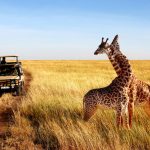
Wildlife Safaris in East Africa are very exciting to travelers due to the fact that they give travelers an opportunity to watch numerous Flora and Fauna inhabit the green habitats in East Africa. These can be spiced up with Mountaineering Adventures so as to get an ultimate African Safari Experience on holiday vacation as you watch Africa’s BIG FIVE animal species and hike to the top of the majestic Mountains of Africa.
Mountaineering Destinations/ Mountains of East Africa
East Africa has several high mountains that offer hikers thrilling adventures while on their holiday in Africa. These include Mountain Kilimanjaro in Tanzania, Mountain Kenya in Kenya, Mountain Rwenzori and other several mountains in Uganda and Rwanda. Below are the different hiking safaris available any time of the year. Feel free to inquire about the prices of each package.
What to Carry For Your Hiking Safari in East Africa
While on your Mountaineering/ Hiking Safari Tours in East Africa we recommend you carry / hire the right hiking Gear to enjoy every moment as you transfer to the top. These include; Rain Jacket, Hiking Boots, Warm Stockings, Gardening Gloves, long sleeved Shirts, Long Pants not jeans, camera, Extra Batteries.
Gorilla and Rwenzori expedition in Uganda | Alpha Adventure Safaris
“Our only 16 Days trip that includes gorilla tracking in Uganda, combined with some superb hiking in the Rwenzori mountains and visit Queen Elizabeth National Park( Optional) “ 2021-2023 $5388 USD PP (Price includes: Ground transportation, driver/guide, all the activities mentioned in the itinerary, park entrance fees, accommodation and meals mentioned.
Price excludes: Tips, souvenirs, all beverages and items of personal nature.)
Gorilla tracking and trekking in Bwindi Impenetrable National Park Kigezi Highlands Rwenzori Mountains National Park 11 days of hiking in Uganda’s mountains and forests Enock’s Falls Mutinda Valley Namusangi Valley Bamwanjara Pass Bugata Lake Banwamjara Pass Bird watching Kacholpe Lakes Scott Elliott Pass Stanley Glacier Mount Stanley Margherita Peak (5,109m) Margherita Glacier Nyamwamba Valley Fort Portal Kibale Forest Chimp tracking Kampala
tinerary
Day 1: Rwenzori Mt. and Gorilla Safari
Airport pick up – Kampala Your driver/ guide will pick you up from the airport. From here he will transfer you to Cassia lodge in Kampala.
Day 2: Rwenzori Mt. and Gorilla Safari
To Bwindi Impenetrable Forest Today you drive to Kisoro in the south-western part of Uganda, close to the borders with Rwanda and Congo. Drive through the “Switzerland of Africa” area known as the Kigezi Highlands with its terraced hillside and winding roads to Bwindi (5 hours). Accommodation at Bwindi Gorilla Haven.
Day 3: Rwenzori Mt. and Gorilla Safari
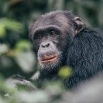
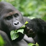
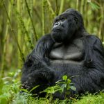
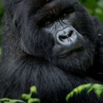
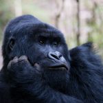
Bwindi Impenetrable Forest – Gorilla Tracking Today is the big day… Prepare yourself for an encounter with one of Bwindi’s gentle giants: the rare Mountain Gorilla. For most people this is the absolute highlight of their tour in Uganda. Bwindi Impenetrable Forest boasts both Mountain Gorillas and Chimpanzees – the only forest in Africa which can make this claim in fact. It also hosts five other species of primate, 113 species of mammal, over 200 butterflies and 360 birds. The Gorillas you will track belong to one of seven habituated family groups who can tolerate the presence of humans for a brief period every day. Your trek will be an exciting journey along forested slopes, entwined vines, bushes and bamboo before you eventually reach the Gorillas’ habitat. En-route, your guide will point out signs of previous Gorilla activity, including dung, nests and chewed bamboo shoots. The time taken to track the Gorillas can take as little as 2 hours to as much as 7 hours before one returns to the camp! Once the Gorillas have been located, your group will be allowed a maximum of one hour with them. Coming face-to-face with a Mountain Gorilla is a truly humbling and emotional experience. This is a fantastic and privileged opportunity to get up close and personal with Uganda’s very own ‘Gorillas in the Mist’. Accommodation at Bwindi Gorilla Haven.
Day 4: Rwenzori Mt. and Gorilla Safari
Drive To Kasese; We depart early today, because it’s a fairly long drive to Kasese at the Trekkers hostel. This is where your simple but reasonable guesthouse is situated. From here you will start the Rwenzori Trekking tomorrow. Trekkers Hostel is 12 kilometres from Kasese town in a deep valley at the end of the road leading to the Rwenzori Mountains National Park. Behind the hostel meanders the Nyamwamba River which is the valley the Kilembe trail follows deep into the Rwenzori Mountains National Park. The sorroundings are delightfully green and you can enjoy the cool weather as the hostel is situated at 1,450 metres which is nearly 500 metres in height above Kasese town. Make sure you bring something to drink and to bite on the way.
Day 5: Rwenzori Mt. and Gorilla Safari
Steady walk with a steep climb for the last kilometer. Start at Trekkers at 1,450 meters and sleep at Sine Hut at 2,596 meters being a height gain of 1,146 meters. We start by walking up the valey floor through tall forest trees of the Afro Montane Forest Zone. This is a steady climb with multitudes of birds and a chance of seeing a wild chimpanzee or blue monkey scampering off through the forest. At times visitors may see troupes of 15 to 20 Colobus monkys scampering through the tree tops. There are rare sightings of the L’Hoest monkey which are part of the Bukonzo cultural emblems and are protected by the virtue of the King or Omusinga. There is wide variety of plant species from forest trees to bamboos thickets, low shrubs, flowers, fungi, and with many moss and lichen covered vines hanging from the tall trees creating an awesome appeal. Enock’s Falls are just 200 meters from Sine Hut and offer a splendid opportunity to capture a great screensaver for your memories. The wooden hut with 10 beds is a set between tall forest trees on a narrow ridge, with ten beds and a large verandah where you may sit and enjoy the beauty of the Afro Montane forest while you look down at a fantastic waterfall crashing over the rocks far below. Sine is just below the bamboo zone and the area around has many different bird species. Sleep at Sine Hut – 2,585 metres.
Day 6: Rwenzori Mt. and Gorilla Safari
After a good breakfast, trekking starts at 8.30am and you soon enter the Bamboo-Mimulopsis Zone which is steep climb with many high steps. In the wet season the bamboo area is rather muddy and slippery making the going slow. However the atmosphere and the forest is beautiful as you climb 551 metres altitude and a distance of 1.8km to Kalalama Camp at 3,147 meters which is in the Heather-Rapanea Zone where you can take a rest and a quick cup of tea or coffee before heading on to Mutinda Camp. The trail meanders up and over several small knolls along a ridge top then drops down the side of the valley before climbing again, and in doing so cross several small streams and passing close to moss covered waterfalls. You then climb steadily along the side of a beautiful mossy river which tumbles down over the rocks under the Giant Heather trees whose trunks are covered in green moss with old man beards (Usnea lichen) hanging from the branches. The trail twists and turns as you climb up the deep valley, which has an enormous variety of plants and flowers. This valley is unique with many Giant Heather trees creating a beautiful atmosphere often shrouded in mist. Eventually you get to Mutinda Camp which is set near a small river that drops off a waterfall and offers a chance to wash, refresh and relax or, you may wish to climb up to the top of the Mutinda Lookout (one and a half hours up and one hour down) The view and the atmosphere is amazing as you stand on moss covered rocks at 3,925 meters with views across the Rwenzori Mountains, down to Kasese town and Lake George.
Day 7: Rwenzori Mt. and Gorilla Safari
4.9km starting at 3,688 meters climbing to 4,062 meters Alpine Zone. The trail here is boggy particularly in the wet season but with a little skill you can step from tussock to tussock to make the going easier. You cross the Mutinda valley through the tussock grass and everlasting flowers interspersed with many Giant Lobelias before climbing a steep section up to the Namusangi Valley (3,840 meters), which ends abruptly with sheer waterfalls and fantastic views of Mutinda Peaks. The Namusangi Valley is wide, with many ups and downs and crossing several bogs as the trail climbs steadily to Bugata Camp at 4,062 meters. Bugata Camp is situated way up Bamwanjara Pass high above Bugata Lake with views across Lake Kopello to Weismann’s Peak, which is often covered with snow then down the valley views of Lake Africa and Lake Kanganyika and the many small peaks towards Mutinda Camp. The area is covered with tussock grass, everlasting flowers (Helichrysum), St John’s Wort (Hypericum becquaeritii), giant groundsel (Senecio adnivalis) and Giant lobelia (Lobellia gibberoa). There are a many Red Forest Duiker (Cephalophuc nigrifrons rubidus) which are a sub-species only found in the Rwenzori Mountains. In the past they have been very hard to see due to the thick vegetation but since the fire, which burnt across the alpine region of the Rwenzori Mountains, they are now easier to see in the new shorter growth. In the dryer season you may choose to walk directly up the valley but a more scenic trail meanders along the hilltops with fantastic views of Lake Nusuranja from Plozza Rock. From Plozza Rock you also get fantastic views down the valley of nine lakes ringed by rugged peaks and ridges Bugata Camp has good facilities, solar lights, good toilets and bathrooms where the guides may prepare some warm water in a basin for you to wash. Bugata also has a heli pad (GPS reading N 18.312 E29 53.457) in case of any need for rescue by helicopter.
Day 8: Rwenzori Mt. and Gorilla Safari
6.2km starting at 4,062 meters climbing over 4,450 meters sleeping at 3,974 meters Commence trekking at 8.30am to climb up Bamwanjara Pass, the trail climbs steadily with several long flat bogs. The area is covered by everlasting flowers and Giant groundsel with the bogs being mainly tussock grass and Giant lobelia whose nectar is the main food source for the Scarlet-tufted Malachite Sunbird (Nectarinia johnstonu dartmouthi) which is common in this area and unique to the Rwenzori Mountains. As you climb you look back to see the glacial lakes far down in the valley. On reaching the top of Banwamjara Pass you get excellent views of all the main snow capped peaks where we have a small shelter for you to rest and enjoy the scenery. The walk down to Kacholpe Lakes is steep and often very muddy but offers fantastic views of Kachope Lakes and McConnell’s Prong. Butawu Camp (3,974m) is set on a ridge high above Butawu River which flows down from Scott Elliott Pass through Kitandara Lakes and has excellent views of the snow capped Mt Baker.
Day 9: Rwenzori Mt. and Gorilla Safari
4.2km Starting at 3.974 meters climbing to 4.485 meters Walk back along the ridge before crossing several wet areas and small rivers coming from Mt Baker and Freshfields Pass to join Butawu River. The walk up Scott Elliott Pass is enjoyable as you climb through the pass and up the ridge of Mt Stanley to Margherita Camp at 4,485 meters which is below Elena Hut. It is sheltered with a ring of high rocks and it is the original camp used by the Italian Prince Luigi Amadeo di Savoia, Duke of the Abruzzi, who mounted a very powerful expedition in 1906, composed of biologists, surveyors, a geologist and a photographer. The Italian led team, between June and July 1906 climbed the mountains, opening a new page in the history of mountaineering and exploration in Africa, and providing an answer to the most unresolved geographical questions in the region for centuries. Some of the peaks still have the names, which the Duke chose to honor the Italian Kingdom and Queen Margherita hence our naming this camp Margherita Camp. From here you have great views of Mt Baker, Scott Elliot Pass and some of the high glaciers on Mt Stanley.
Day 10: Rwenzori Mt. and Gorilla Safari
Day starts at 4,485 meters climbs to Margherita Peak at 5,109 meters return to Margherita Camp then descend to Butawu Camp at 3,974 meters to sleep. Distance 3.5km to the peak then 3.5km return to Margherita Camp plus 4.2km down to Butawu Camp.Total distance 11.2km. Wake up at 4.30am have a quick snack and start climbing so as to get on the Stanley Glacier before sunrise. The climb up from Elena can be difficult if covered in snow and ice but it is classed as a difficult scramble. Once on the Stanley glacier the going is easy however, the climb to Margherita glacier can be challenging and slippery in bad weather. Rwenzori Trekking Services has recently installed a new fixed static rope with bolts every three meters leading down a ledge to the top of a six-meter aluminum ladder. This is a safe route and anyone with reasonable fitness and head for heights is able to pass. It is not classed as technical and it is easy in dry conditions. The climb up Margherita glacier is steep and requires that you are fit. On getting near to the top of the glacier you then climb around an exposed section of rock, which is also bolted and roped, to get on the ridge running up to the top of Margherita Peak. On a clear day the views from Margherita Peak are awesome and your goal is achieved! After summiting you then descend directly to Butawu Camp or in the case of bad weather, you may need to stay in Margherita Camp however the following day it will be necessary to bypass Butawu Camp directly to Bugata Camp.
Day 11: Rwenzori Mt. and Gorilla Safari
6.2km starting at 3,974 meters climbing over 4,450 meters sleeping at Bugata Camp 4,062 meters A late breakfast at 8.30am start trekking by 9am. The climb up Bamwanjara Pass which is steep and in wet weather can be rather boggy making it slow going and tiresome. While crossing the pass you get the chance to see hyrax sitting at the entrance to their rock shelter warming in the sun. Their main predator is the Rwenzori Leopard Panthera pardus ruwenzori, which is rarely seen, but occasionally people do get a glimpse. The leopard has been heavily poached for it’s skin in the past and there are few left. There is a skeleton nearby in a small rock shelter for those who doubt the existence of leopard at those heights. However on a rare occasion on a misty or overcast day, you may be lucky to see one briefly as they move between the rocks. Sleep at Bugata Camp.
Day 12: Rwenzori Mt. and Gorilla Safari
Descend to either Kiharo Camp 3,460 metres or Samalira Camp 3,170 metres Early morning set off around Lake Bugata and the outlet of Kopello Lake then climb 200 metres to the confluence of the two valleys . As you descend down the upper areas of the Nyamwamba Valley there is a large area of thick Giant Groundsel with dense evergreen undergrowth and moss with the rocky peaks towering above. As you descend the valley you will notice the terrain is made up of several flat boggy areas where millions of years ago glaciers sat and melted leaving a wall of big rocks in front of where it lay. The valley is home to many Red Forest Duiker (Cephalophuc nigrifrons rubidus) At night you may stay in Kiharo Camp at 3,460 metres an area rich in evergreen plants and babbling streams. At night the air is filled with the calls of the rock hyrax as they sit in the rocky cliffs high above. Note:- As it is necessary to skip one of the camps you may either stay in Kiharo and enjoy the lush vegetation and rocky cliffs or may descend to Samalira Camp at 3,170 meters making a shorter trek down to base camp the following day.
Day 13: Rwenzori Mt. and Gorilla Safari
Assuming that you slept in Kiharo Camp, you wake up to the shrill calls of the Ruwenzori Turaco (Ruwenzorornis johnstoni) and other birds. After a hearty breakfast you walk down the valley which is home to many species of birds who dive in and out the thick vegetation. Chameleons are a common sight as they crawl along the branches of the thick vegetation feeding on insects. In the clear areas you may catch a glimpse of a Duiker quietly feeding surrounded by Giant Lobellias and a variety of flowering plants. After descending a few kilometres you climb two hundred metres height to a ridge overlooking the valley before crossing several small valleys and streams to Kyalavula which means view or lookout in the local Bakonzo language with beautiful views down the valley and across to Lake Edward in Queen Elisabeth National Park. Samalira Camp 3,147 meters is situated in a closed valley at the top of several waterfalls and is the alternative to sleeping In Kiharo Camp. From here you descend down a long ridge, through the Bamboo-Mimulopsis Zone and Afro Montane Forest Zone back down to base camp in Kilembe.
Day 14: Rwenzori Mt. and Gorilla Safari
Crater lake hike Fort Portal – Kibale Forest After a 2 hour drive to Fort Portal you can stretch your legs by making a nice hike around some of the Crater Lakes in this Area. The views are stunning and with clear weather you can even see the white peaks of the Rwenzori Mountains. You have lunch in Fort Portal as well (not included) After this hike it’s only 1 hour driving to Kibale Forest. On arrival, you will enter a completely different world… some serious monkey business! Although you are here specifically to track Chimps, the forest is home to at least 12 primate species including: the Red Tailed Monkey, Olive Baboon, Black and White Colobus Monkey, and the Blue Monkey. The bird life in the forest is also prolific and includes the beautiful Great Blue Turaco. If you are very lucky, you may even catch a glimpse of the meandering herd of Forest Elephant. Accommodation at Kibale Forest Camp.
Day 15: Rwenzori Mt. and Gorilla Safari
Chimp tracking and swamp walk in Kibale Forest Today, you will track Chimpanzees and do a swamp walk. Kibale Forest boasts the highest number of primate species in the world, including our delightful cousins, the Chimpanzees. Today, in Uganda, there are approximately 4,950 Chimps left in the wild, which makes it a perfect place to spot them! (Although this cannot be guaranteed). During the trek, your ranger will point out the other species living in the forest, including birds, flora and fauna. Your swamp walk (2-3 hours) will take you through grassland, small communities and some beautiful scenery, where the locals are likely to greet you with enthusiastic waves. It is usual to spot 3 or 4 different primate species during this walk, though the highlight is catching a glimpse of the Great Blue Turaco! If you are tired from the Chimpanzee tracking you can do this walk as well tomorrow morning. Accommodation at Kibale Forest Camp.
Day 16: Rwenzori Mt. and Gorilla Safari
Return to Kampala – Airport transfer Today, after an early breakfast, you return to Kampala. From Kampala we drive to Entebbe airport for your flight connection. Make sure your flight departs after 8 pm to make sure you can make this program. If your flight leaves earlier we suggest booking an extra night in Entebbe.
Our Top Mountaineering Safari Packages
- 5-Day Kenya Mountain Hiking
Visit Mountain Kenya
Enjoy the five days tour of Kenya. Visit Kenyas main natural attractions and experience the endless interesting hike.
- 5-Day Mt. Kilimanjaro Hiking Tour
Visit Mountain Kilimanajro
Hike up the majestic Mountain Kilimanjaro while on holiday vacation tour in Tanzania to enjoy the best hiking safari Adventures in Africa.
- 6-Das Sirimon Out Chogoria
Visit Mountain Kenya
Experience remarkable Hiking Safaris in Kenya as you hike to the top of the beautiful Mountain Kenya while on holiday tour in Kenya.
- 8-Day Mountain Rwenzori Uganda
Visit Mountain Rwenzori
Mt Rwenzori is one of the block mountain found in East Africa, it lies on the boarder of Uganda and Democratic republic of Congo.
Uganda Mountain Hiking & Climbing Safaris
9 Day Rwenzori Mountains Hiking Safari
Mt. Rwenzori Safari Overview
The Rwenzori Mountain Hiking safari has been described by many of our travelers as an exhilarating African safari experience that deserves a great rating. Take fro example one who said: “Starlight beamed down on the convex glaciers surrounding our camp near Uganda’s western border, causing them to glow like resting lunar crescents.”
The Rwenzori Mountains, or the “Mountains of the Moon”, have a celebrated beauty. Shrouded almost perpetually in mist, they have a seducing, eerie quality that led to many wondrous tales about them through the ages.
Rwenzori is known primarily for its challenging hiking and climbing possibility with a unique among East African Mountains. Rwenzori is not Volcanic in Origin, but it rises directly from the Rift valley floor. Its range also supports a diversity of animals including mammals and about 177 bird species, with several being Albertine Rift Endemics. It’s the highest mountain range in Africa, with its Loftiest peaks, Margherita (5,109m) and Alexandra (5083m) on Mount Stanley, are exceeded in altitude elsewhere in Africa only by Kilimanjaro and Mt. Kenya.
Safari Highlights
- Marvel at views from the summit of Margherita Peak (5109m)
- Trek in the UNESCO World Heritage listed Rwenzori Mountains, a source of the River Nile
- Discover remote alpine valleys and glacial landscapes
- Experience pristine tropical rainforests
- Trek through Giant Lobelia forests along the remote Kilembe Trail
- Delight in the diverse flora of the region
Know before you go
You’ll be taking a country road trip of about 6 hours to Rwenzori Mountains NP and hiking high up Mt. Stanley (5109 metres).
The tour is limited to a maximum of 6 travelers per vehicle, and 30% deposit on confirmation.
Detailed Itinerary
- Day 1: Entebbe – Rwenzori Mountain National Park
After breakfast and the briefing on the Rwenzori mountains hiking safari, we will take off to the Rwenzori Mountain National Park (also known as the Mountains of the Moon). The drive will take approx. 7 hours. We will have lunch in Fort Portal and then continue to Mihunga where we overnight.
The equatorial snow peaks include the third highest point in Africa; Margherita (5109 metres), Alexandria (5083 metres) and Albert (5087 metres)
Accommodation and meals:
Mihunga Lodge
Breakfast, Lunch and Dinner
- Day 2: Trek to Nyabitaba (2650 metres)
You will start your Rwenzori mountains hiking safari challenge with the trek to Nyakalengija trail head (1600 metres) where the Uganda Wildlife Authority (UWA) will provide and informative briefing prior to commencing the trek. Our trek will take us past Bakonjo homesteads dwarfed by steep foothills and banana plantations. We will follow the trail along the Mubuku River to then cross the Mahoma River before steadily climbing through Podocarpus Forest.
Accommodation and meals:
Nyabitaba Hut (2650 metres)
Breakfast, Lunch and Dinner
- Day 3: Trek to John Matte Hut (3350 metres)
Third day of the Rwenzori mountains hiking safari will start off from Nyabitaba early after a substantive breakfast. We will follow a small trail dropping down through the forest to the Kurt Shafer Bridge, just below the convergence of the Bujuku and Mubuku Rivers. The forest gradually turns into a bamboo zone where the trail is slippery and moss covered. A zone of the giant heather, lobelia and groundsel vegetation emerges before the Nyamileju rock shelter before traversing a bog to the hut.
Accommodation and meals:
John Matte Hut (3350 metres)
Breakfast, Lunch and Dinner
- Day 4: Trek to Bujuku Hut (2900 metres)
Continue the Rwenzori mountains hiking safari on a trail that crashes down to cross the Bujuku River and enters Lower Bigo Bog, home of giant lobelias. We will cross the bog to the Upper Bog before continuing to Lake Bujuku where views of the highest mountain can be seen.
Accommodation and Meals:
Bujuku Hut (3900 metres)
Breakfast, Lunch and Dinner
- Day 5: Trek to Elena Hut
After Bujuku, we will climb the boggy trail up the slopes west of the lake, passing through the paranormal groundsel gully and then ascend to the Scott Elliott Pass (4372 metres). A metal ladder will take you oven an extremely steep section after which the trail branches; the right one leads up to Elena Hut and Mt. Stanley over a steep rocky trail, the left leads to the Scott Elliot Pass and down to Lake Kitandara.
Accommodation & meals:
Elena Hut (4541 metres)
Breakfast, Lunch and Dinner
- Day 6: Ascent to Mt. Stanley (5109 metres) to Kitandara Hut (4027 metres)
For Rwenzori mountains hiking safari travelers that do not wish to climb the peak, a more restful day walking from Elena Hut (4541 metres) to Lake Kitandara (4023 metres). For those who wish, but also depending on altitude sickness, visibility, climbing ability we will climb a further three hours to Margherita peak (5109 metres) and later down to Kitandara Hut. We will trek to the Elena glacier before moving on to the Stanley Plateau. We will climb and scramble to the Margherita summit, the highest point of the Rwenzori. The use of crampons and ropes may be necessary. We will need to be prepared for a tough, arduous time in the mountains. We will then return to the Scott Elliot pass, view the magical Bujuku Lake and Mt. Speke at a distance and will then continue down to Lake Kitandara.
Accommodation & meals:
Kitandara Hut
Breakfast, Lunch and Dinner
- Day 7: Trek to Guy Yeopman Hut (3260 metres)
After breakfast we will climb from the base of Mt. Baker to the south side of the mountain to the Fresh Field Pass (4280 metres). From there we can view the Congo to the west, Mt. Stanley to the north. From the pass, the boggy trail will continue downwards, passing the rock shelter at Bujangalo, the base camp for the historic expedition by the Duke of Abruzzi in 1906.
Accommodation & meals:
Guy Yeoman Hut (3262 metres)
Breakfast, Lunch and Dinner
- Day 8: Trek to Nyakalengija Trail Head (1600m ASL)
The trail to Nyabitaba Hut can be muddy and very slippery under foot.
Accommodation & meals:
Nyakalengija trail head
Breakfast, Lunch and Dinner
- Day 9: Transfer back to Entebbe
Your Rwenzori mountains hiking safari driver will meet you at your stay, check you out and transfer you back to Entebbe in time to catch your flight back to Entebbe.
Accommodation & meals:
No Accommodation
Breakfast, Lunch
END!
Uganda Mountaineering and Hiking Safaris-Uganda safari toursUganda Mountaineering and Hiking Safaris-Uganda safari Tours
Uganda is still an undiscovered gem when it comes to mountaineering and hiking safaris. Uncongested trails characterize your Uganda mountaineering and hiking safari. Uganda is blessed with beautiful mountain ranges, amazing terrain that makes a good hike. The snow-capped ranges of Rwenzori Mountains and Mt Elgon offer long and exciting time on high altitudes while shorter ranges like Mt Sabinyo and Mt Muhabura offer shorter hiking excursions. These Uganda mountaineering and hiking safaris can be coupled with other Uganda safari activities like gorilla trekking, wildlife safaris, chimpanzee trekking and cultural tours.
Uganda’s popular mountaineering and hiking destinations include; Mountain Rwenzori, Mt Elgon, Mt Sabinyo, Mt Muhabura, Sipi falls and Mt Mgahinga. These mountains offer a different terrain ranging from rocky grounds, crater lakes, alpine regions and bamboo forests